Monthly Archives: August 2014

Golden Dip

My beautiful picture
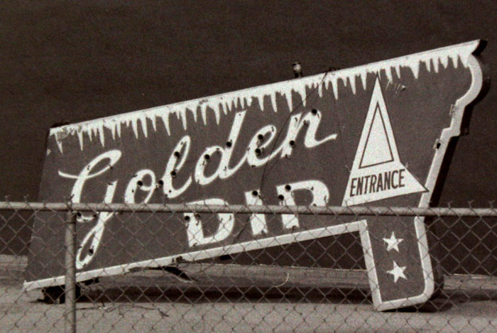
I took this picture sometime in the late 70s.  This sign was in a vacant lot, propped up against a wall, in Highland.  The Golden Dip soft-serve ice cream place was at 2300 Ft. Henry Drive, in what we then called Litz Manor, roughly where McDonalds now sits, across from the Masonic Lodge.
Conley (or Connelly, it’s spelled both ways in the 1959 Kingsport City Directory) Brookshire owned this place and the Holston Drive In, further out on Ft. Henry Drive, about where Woodstone Deli is.  I worked at both places when I was about 12 or 13.  Con Brookshire and his wife were really fine people.

Upper Gregg Cemetery

In 2005, after a year or so recording the old foundations of homes and the old school at Bays Mountain Park,  Following a rather difficult path that I had picked out using a calibration between an old plat map and a modern topo map of the park, I located the Upper Gregg (or Gragg) Cemetery.  There are two readable stones here, the rest have eroded to blanks.
uppergreggstone1

On this one is carved, “John M. Brown Born Mar. 23, 1820. Died Sep. 21, 1880. Blessed are the pure in heart for they shall see God”
In Muriel Millar Clark Spoden’s self-published pamphlet “The Early Years on BAYS MOUNTAIN in Sullivan County, Tennessee” (1975, Franklin Printing), she records comments by a elderly descendant of the Gregg family commenting on the incongruity of having a Brown in the Gregg Cemetery.  “…how did he come in on this?”

There’s another stone with readable letters on it:

uppergreggstone2

J. M. B.  That’s it.
The cemetery is on a hillside overlooking the lake.  The graves face east, to the rising sun.
I have pictures of the lower cemetery.  I’ll post them later, but all the stones there were blank.

Kingsport Chamber handout

chamberbooklet


This is a 10-page (plus cover & back), Kingsport Chamber of Commerce (A. B. Coleman, Executive Vice-President) piece from 1957.  Its cover matches a 1948 one I have in all but color: the 1948 one has a green fill.  And the 1948 one was published by the Kingsport Rotary Club, this one was done by the Chamber.  Ellis Binkley worked on both of them.  Both printed by Franklin Printing Company (up on Main Street…it always smelled great, of paper, of ink…the same smell a newspaper building should have).  Quite a few black-and-white photos in both of these…some duplicated, but others showing the passage of nine years.

The 1948 issue has a map on the back cover.  I never knew that Highway 11 (now the Robert E. Lee Highway)(Stone Drive, of course) was known as the “Broadway of America Highway”.  Wikipedia neglects to mention this.

Both pieces, though, are pretty much textbook promotion handouts for that post-war period.
Remember, it’s said that Chicago isn’t called “The Windy City” because of its weather, but for its indefatigable promoters.

Honest John’s, Kingsport TN

honesdtjohns
This is a fairly common card, a Haynes Distributing Company issue out of Roanoke VA.  Chrome, of course.  Plate number is 45031-B.
On the reverse: “BIG INDIAN, 32 feet tall  Weight 10,000 pounds  Located on Stone Drive Super Hiway Route 11W, Kingsport, Tennessee
As far as known, it is the world’s largest wooden Indian.  Built by Honest John.
Honest John’s Gift Shop, John D. Barker, owner”
There’s interesting information on this indian here.
Pratt’s bought the building in 1971.
In the message area on this card, in ball point pen, script:
“Helen   1972-card sent”
The address:  Pratts, 1225 E Stone Dr.  Kingsport, Tenn
It was never sent.

I am told that when this statue was in its original location on Memorial Boulevard (the old Bristol Highway, about halfway up to Edens Ridge), Honest John (Barker) had a loudspeaker installed in it.  He would use an attached amplifier and microphone to issue cheery greetings to tourists passing by.

Probably freaked the hell out of them…


Kingsport TN from Cement Hill

kptfmcementhill

“A BIRD’S EYE VIEW OF KINGSPORT, TENN., FROM “THE CEMENT HILL”
This postcard is interesting for several reasons, the first being that it was actually used, so there’s a postmark on the back.  It was mailed in 1931 from Kingsport by a couple passing through on the way to Knoxville and addressed to a lady in Reidsville North Carolina, R.F.D. #6.
It’s also a reasonably scarce issue by T.J. Stephenson of Kingsport (he took the picture) and printed by Tichenor Dual Views (Tichenor Brothers of Cambridge MA), plate #121031.  You don’t have to look very carefully to see that it is a black & white photograph that’s been rather crudely colored in by the publisher.  Stephenson had a whole line of postcards with pictures of Kingsport taken in the mid- to late-20s.  I love these cards and don’t have all in the series.  I saw one of Catawba Street that I so badly wanted to snatch out of the owner’s hand and sprint off with, but, sadly, I didn’t.

Last House on Cement Hill

I had a paper route in the late 50s that included the homes on Cement Hill.  It was a difficult bike ride up, but a thrill going down (I misjudged one time and ended up in a pile of gravel).  The homes were quite nice, with the ones on the Industry Drive side having mysterious (to me) back yards that went down the side of the hill to the woods.  This home was on the curve of the road on the Kingsport side.
lasthouse

The old Rialto

I’m standing on Cherokee Street, the crane is sitting on New Street.  Around 1980 or so, somebody, maybe the city, decided to tear down the old Rialto Theater building.  When I was a kid, it was referred to as “The Rathole” and mom wouldn’t let me go there.  By the time of this picture, it had been AY’s Restaurant for a number of years and I think there had been a billiards parlor (pool hall) in that side door.  Upstairs were apartments.
oldrialto


Kingsport Brick Company

This is a Kingsport Drug Store issue, printed by Curt Teich Company in Chicago (as best as I can tell, from the dating system for CT, this is an AD (for Doubletone) card from around 1917).  Kingsport Brick became General Shale.  This plant is no longer operational and has been seriously vandalized.  Those round kilns have been gone for years.
In the late 50s, from our apartment in downtown Kingsport, I noticed a fire at this plant.  I grabbed by Argus camera and hurried over there.  As I was taking a picture of the building on fire, a man walked up to me and introduced himself as Ellis Binkley, editor of the Kingsport Times-News.  “Come see me, boy,” he said, “when you graduate and I’ll have you a job as a photographer.”  I said I would.
Turns out, after I got out of service, I hired on at the Times-News, then on Market Street, as a night shift photographer.  Mr. Binkley, by that time, was mostly retired and I don’t think I ever reminded him of the encounter at the brick plant.
kingsportbrick2

Old Sluice Bridge

I didn’t even know this stupid old bridge was still in place.  It’s been out of use for decades. This bridge connected the Springdale Community, South Eastman Road, to Long Island.  Eastman Road then went across the Island to another, long gone, bridge that went right into Eastman.  I once lived in Springdale, but we didn’t have a car then, so I wasn’t at all familiar with these bridges.  If we caught a bus to town, we went via Wilcox Drive. My buddy, though, who lived in Edgewood, vividly remembers his school bus easing by oncoming traffic on this bridge. It’s only about 17′ wide (and about 220′ long).  This is looking toward Springdale.  It’s still pretty sturdy, but the piers are starting to crumble.  There was no date plate on either section.
OLYMPUS DIGITAL CAMERA


Here’s an aerial shot of Eastman from the late 40s or so.  It shows the bridge I mentioned above and you can also see a little bit of Edgewood Village in the upper left quadrant.
eastmanlate40s