
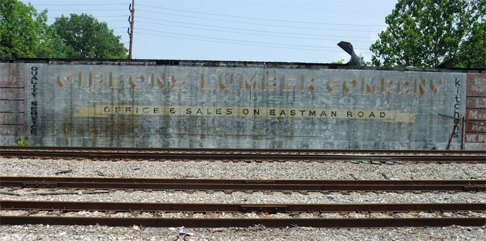
For ages, this sign would have been right in front of you if you were coming off North Eastman Road onto Lincoln.
I took this in 2011 and it was fading rapidly at that time.
(thank you to a commenter who corrected my title for this post)
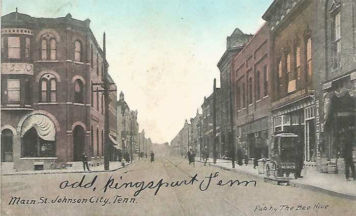

This is one of my favorite cards. It was mailed in Kingsport, probably at the Big Store, July 25, 1910.
On the front, in ink, is “add, kingsport Tenn”
Below that: “Main St. Johnson City, Tenn. Pub. by The Bee Hive”
(you can still see The Bee Hive sign in downtown Johnson City)
On the back:
It’s addressed to Mrs. Claud Jolly, Rockmart Ga
The message:
Dear Mrs Jolly
How are you we are well. I suppose you are in Rockmart by now. Our chickens are all o.k. Mother is with us again. We are getting along fine. Hope you will be able to visit some time. There isn’t much here yet, but building. just 28 houses here now. Answer soon. Love to you all also the ?mother?. Mrs. L. E. Mahan
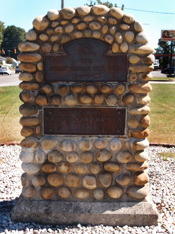
Yeah, it’s hard to read, but check it out yourself. This is on West Stone Drive, more or less in front of the fire station. I know of two of markers like this, the other is on West Sullivan Street:
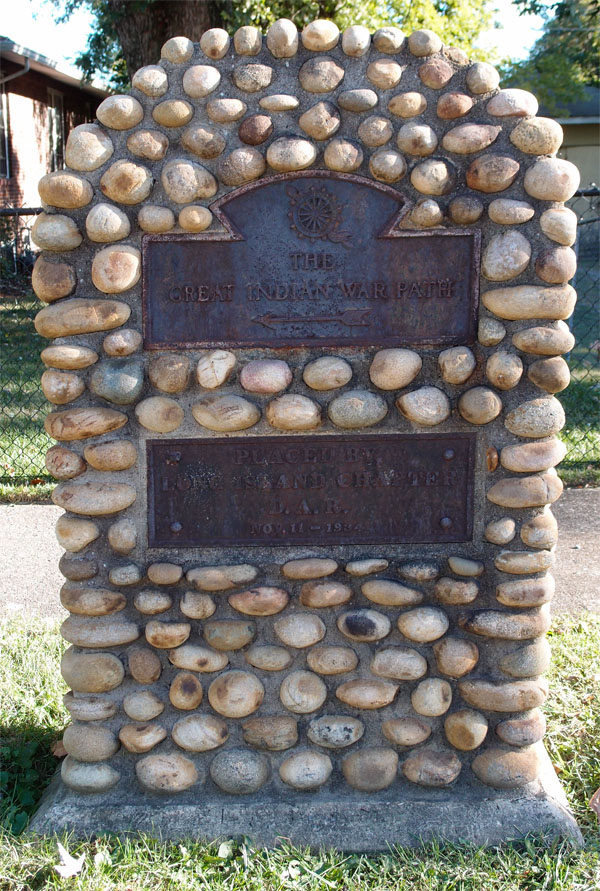
The inscription on both reads:
at top: The Great Indian War Path (with an arrow pointing left)
below: Placed by the Long Island Chapter D.A.R. Nov. 11 – 1934

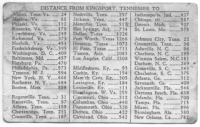
The Liberty Cafe, managed by Charles Joseph and Stellis Mallis (Mallis is an old restaurant name in Kingsport…note the name on the building about halfway down the 100 block of West Main Street), was located where “The Pub” is today on Five Points. I vaguely recall the establishment, or maybe just the sign that remained after the restaurant had closed. This 3-1/2 x 4-1/2 card is pretty dingy – I cleaned it up in Photoshop. I don’t have the foggiest idea where I got it. It might have been my stepfather’s…I think he stayed in one of the rooms above the restaurant for a while back in the ’40s.
On the other side is a convenient listing of distances to various other places.
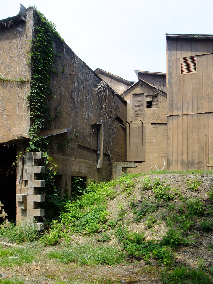
This is a rear view of the building on Netherland Inn Road that once was Cherokee Ice House. It’s been heavily remodeled in the front, but they left this mostly alone. On the left was the ice room. Underneath, through those two openings, were the compressors and brine circulaters.
Ice, for a time, was the intermediate technology, like the cassette tape, in a way. It did the job, but not real well. Then, ice was heavy and always messily changing to liquid water…cassettes didn’t have those problems. They were pretty crappy, though.
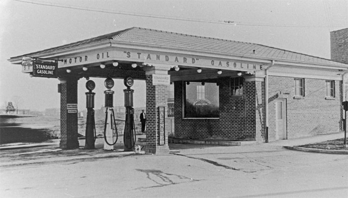
Baker-Clardy Service Station was on the corner of West Sullivan and Roller Streets, where the Funtastics (old Penley’s) building used to stand. This picture was taken when the building was brand new, sometime prior to 1929, when Baker-Clardy ran several ads in the Kingsport Times News.
The signs on the station, which are even hard to read in 4k resolution, offer:
Tourist Information
Ladies Rest Room
Standard Gasoline (Standard Oil Company, probably Standard Oil of New Jersey, later ESSO, later EXXON)
Batteries charged installed
Alcohol (huh?)
Standard Motor Oil
Expert Alemite Service (lubrication…the company’s still in business)
Note the dude standing in the background. He’s checking out the photographer.
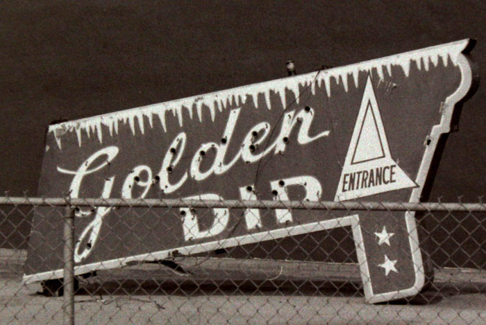
I took this picture sometime in the late 70s. This sign was in a vacant lot, propped up against a wall, in Highland. The Golden Dip soft-serve ice cream place was at 2300 Ft. Henry Drive, in what we then called Litz Manor, roughly where McDonalds now sits, across from the Masonic Lodge.
Conley (or Connelly, it’s spelled both ways in the 1959 Kingsport City Directory) Brookshire owned this place and the Holston Drive In, further out on Ft. Henry Drive, about where Woodstone Deli is. I worked at both places when I was about 12 or 13. Con Brookshire and his wife were really fine people.
In 2005, after a year or so recording the old foundations of homes and the old school at Bays Mountain Park, Following a rather difficult path that I had picked out using a calibration between an old plat map and a modern topo map of the park, I located the Upper Gregg (or Gragg) Cemetery. There are two readable stones here, the rest have eroded to blanks.

On this one is carved, “John M. Brown Born Mar. 23, 1820. Died Sep. 21, 1880. Blessed are the pure in heart for they shall see God”.
In Muriel Millar Clark Spoden’s self-published pamphlet “The Early Years on BAYS MOUNTAIN in Sullivan County, Tennessee” (1975, Franklin Printing), she records comments by a elderly descendant of the Gregg family commenting on the incongruity of having a Brown in the Gregg Cemetery. “…how did he come in on this?”
There’s another stone with readable letters on it:
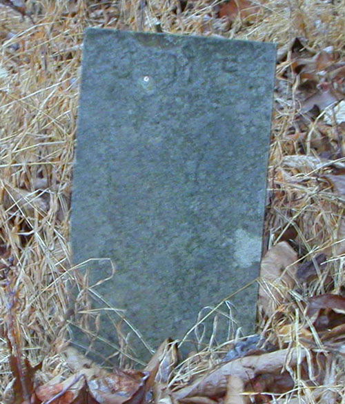
J. M. B. That’s it.
The cemetery is on a hillside overlooking the lake. The graves face east, to the rising sun.
I have pictures of the lower cemetery. I’ll post them later, but all the stones there were blank.
This is a 10-page (plus cover & back), Kingsport Chamber of Commerce (A. B. Coleman, Executive Vice-President) piece from 1957. Its cover matches a 1948 one I have in all but color: the 1948 one has a green fill. And the 1948 one was published by the Kingsport Rotary Club, this one was done by the Chamber. Ellis Binkley worked on both of them. Both printed by Franklin Printing Company (up on Main Street…it always smelled great, of paper, of ink…the same smell a newspaper building should have). Quite a few black-and-white photos in both of these…some duplicated, but others showing the passage of nine years.
The 1948 issue has a map on the back cover. I never knew that Highway 11 (now the Robert E. Lee Highway)(Stone Drive, of course) was known as the “Broadway of America Highway”. Wikipedia neglects to mention this.
Both pieces, though, are pretty much textbook promotion handouts for that post-war period.
Remember, it’s said that Chicago isn’t called “The Windy City” because of its weather, but for its indefatigable promoters.
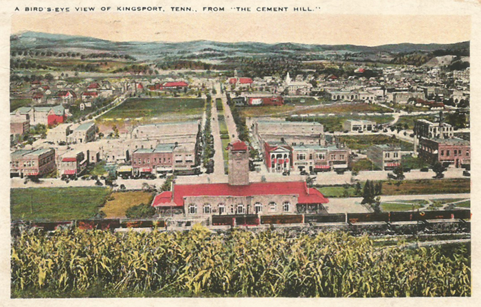
“A BIRD’S EYE VIEW OF KINGSPORT, TENN., FROM “THE CEMENT HILL”
This postcard is interesting for several reasons, the first being that it was actually used, so there’s a postmark on the back. It was mailed in 1931 from Kingsport by a couple passing through on the way to Knoxville and addressed to a lady in Reidsville North Carolina, R.F.D. #6.
It’s also a reasonably scarce issue by T.J. Stephenson of Kingsport (he took the picture) and printed by Tichenor Dual Views (Tichenor Brothers of Cambridge MA), plate #121031. You don’t have to look very carefully to see that it is a black & white photograph that’s been rather crudely colored in by the publisher. Stephenson had a whole line of postcards with pictures of Kingsport taken in the mid- to late-20s. I love these cards and don’t have all in the series. I saw one of Catawba Street that I so badly wanted to snatch out of the owner’s hand and sprint off with, but, sadly, I didn’t.
